Boat Moorings At Tongue Bay
© Official Local Whitsundays Website
Below you will find the information needed for boat owners that want to access Hill Inlet Lookout from Tongue Bay. As this is the main access point for the walk to the lookout and Whitehaven Bay it’s essential to know which moorings you can use for the size of your vessel.
Where is Tongue Bay?
Located on the northern side of the inlet this mooring and anchoring location gives shelter from the prevailing southerly winds that occur in the Whitsundays 80% of the year. Use these moorings for access to Hill Inlet and Betty’s Beach
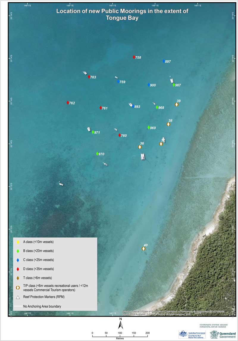
Location Of Moorings At Tongue Bay
Below you will find a table of the moorings along with the classification and vessel length that are allowed to use them, you will also find the GPS location for each boat mooring.
| Mooring Class | Max Length Of Vessel | GPS Location |
| B | 20 Meters | 20° 14.302’S 149° 01.120’E |
| B | 20 Meters | 20° 14.346’S 149° 01.087’E |
| B | 20 Meters | 20° 14.386’S 149° 01.070’E |
| B | 20 Meters | 20° 14.437’S 149° 00.970’E |
| B | 20 Meters | 20° 14.395’S 149° 00.961’E |
| C | 25 Meters | 20° 14.296’S 149° 01.011’E |
| C | 25 Meters | 20° 14.344’S 149° 01.040’E |
| C | 25 Meters | 20° 14.256’S 149° 01.100’E |
| C | 25 Meters | 20° 14.302’S 149° 01.070’E |
| D | 30 Meters | 20° 14.347’S 149° 00.976’E |
| D | 30 Meters | 20° 14.248’S 149° 01.042’E |
| D | 30 Meters | 20° 14.401’S 149° 01.014’E |
| D | 30 Meters | 20° 14.337’S 149° 00.912’E |
| D | 30 Meters | 20° 14.287’S 149° 00.954’E |
Image and PDF download of Tongue Bay mooring locations
Mooring Wind Protection From
Wind protection from the following winds
- North
- North West
- West
- South West
- South
- South East
Further Mooring Information For Surrounding Islands
For a full list of public moorings available around the Whitsunday Islands see this brochure from the Queensland Government Parks and forests website here
[forminator_form id=”244492″]
Hi, I’m Nath J, a long-time local who’s been lucky enough to live and work tourism in the Whitsundays since 2001.
Over the past two decades, I’ve helped visitors discover the best of this incredible region, from Whitehaven Beach and Hill Inlet to the hidden spots only locals know about. I started out managing boats and tours, and these days I run Ripple Effect Online, a tourism-focused digital marketing business helping local operators grow and connect with travellers like you.
I’ve written an ebook called Whitsunday Islands: A Journey through Paradise, created countless local travel guides, and earned recognition as a “Whitsundays Tourism Hero” from QTIC for my contribution to the region and gained First Nations Cultural Protocol training through QTIC as well. But more importantly, I’ve spent years listening to travellers, understanding what makes a trip unforgettable, and helping people plan the kind of experience they’ll talk about for years.
If you’re planning a visit to Whitehaven Beach or anywhere in the Whitsundays, I’m here to help you make it amazing.
Find me on Facebook and LinkedIn or drop me an email at info@nath-j.au.

